Progress
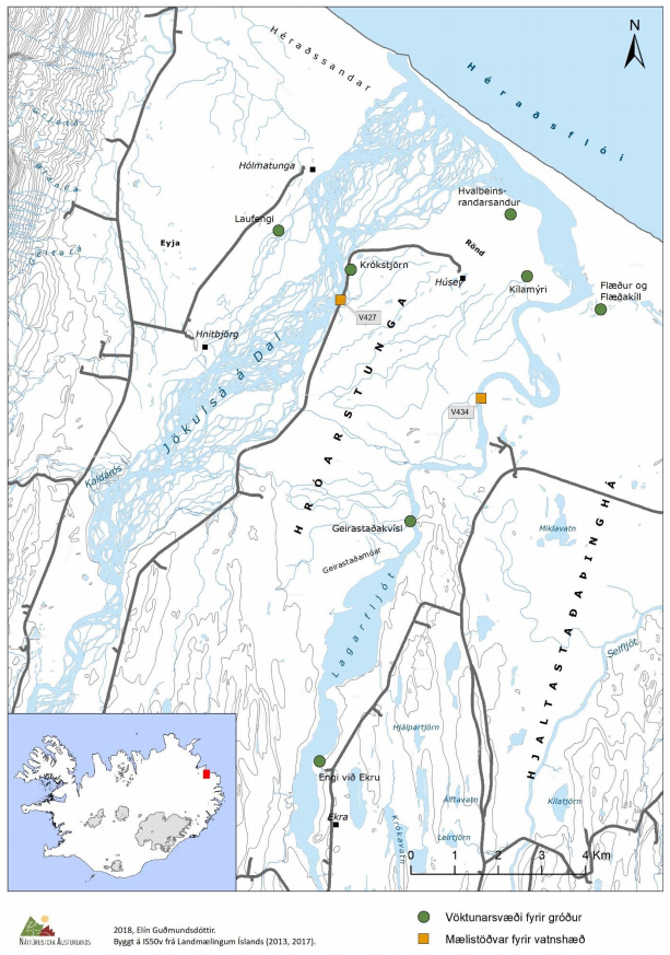
Following the Kárahnjúkar power plant, changes took place in the watercourse of Lagarfljót and Jökulsá á Dal, which were thought to be able to affect vegetation in the vicinity of the rivers in the lowland areas of Úthérað. With the power plant, the water level in Lagarfljót rose but dropped in Jökulsá á Dal. In 2006, vegetation and groundwater level monitoring began in Úthérað. The aim was to study the effect of changes in water volume of Lagarfljót and Jökulsá á Dal rivers on vegetation and groundwater level. Research sites were set up in seven areas along the rivers that were considered most likely to be affected, five areas by Lagarfljót and two by Jökulsá á Dal. Initially, the monitoring was carried out by the Icelandic Institute of Natural History, but East Iceland Nature Research Center took over the project in 2017.
There are 34 permanent plots in the research areas along with the two rivers. The plots are located in different vegetation types; wetlands, heathland, and sands. In addition to vegetation measurements, the groundwater level was measured, and signs of grazing were documented. In data analyses, Landsvirkjun's findings on water levels in the rivers and groundwater levels along the rivers were also used.
The groundwater level has mostly followed changes in the water level of the rivers (LV-2012-099 Icelandic only). In 2013, a vegetation study in the lowest areas indicated changes in vegetation (NÍ-13006 Icelandic only). Based on that, a transect for groundwater measurement was added in Kílamýri moor in the land of Húsey in autumn 2013. The groundwater level follows essentially the same processes as occur in flatlands by rivers, i.e., following the river's water level a few hundred meters from the shore but further from precipitation and thawing (Memorandum EA, 28.01.15 Icelandic only).
The results of vegetation measurements show that there have been changes in vegetation. The changes vary from region to region and are related to changes in groundwater levels and are also shaped by conditions. In areas by Lagarfljót, land has become wet, and wetland species cover has increased. At Jökulsá á Dal, there are indications that the land has dried up to some extent and wetland species cover has decreased. Based on the results of this study, it can be assumed that vegetation will continue to change for the time being.
Metrics, Targets and Monitoring Protocol
Metrics: What is measured?
- In research fields, vegetation is monitored, e.g. total cover, cover of plant species and height of vegetation. Grazing marks are also recorded (Project effect: indirect).
- Groundwater level is monitored (Project effect: indirect).
Monitoring Protocol
Vegetation will be monitored in research fields and the results will provide information on changes in species composition and vegetation cover. Vegetation measurements are carried out every 5-10 years. Measurements will be made of the groundwater level annua
Targets
Investigate the effects of changes in the watercourse of Lagarfljót and Jökulsá á Dal following the Kárahnjúkar power plant on vegetation and groundwater levels.
Possible countermeasures
Not applicable, monitoring only.
Changes of indicator
This indicator was originally number 29.1b. It was then named Movement of Coastline and can be found under that number in documents of the project from 2005 and 2006.
The indicator number has been changed twice.
| Year | Nr. | Indicator name |
|---|---|---|
| 2020 | 2.6.3 | Vegetation in Úthérað |
| 2007 | 2.6b | Changes in the Coastline of Héraðsflói bay |
Baseline
The basic condition of the area was examined in 2006 and the results are available in the report The basic condition of the area was examined in 2006 and the results are available in the report Gróðurvöktun á Úthéraði Áhrif vatnsborðsbreytinga í Kárahnjúkavirkjun (Icelandic only).
Rationale for Indicator Selection
Following the Kárahnjúkar power plant, it was expected that changes would be made to the watercourses of Lagarfljót and Jökulsá á Dal in Úthérað. It was assumed that the water level in Lagarfljót would rise but fall in Jökulsá á Dal. Due to these changes, it could be assumed that areas close to Jökulsá á Dal would dry up to some extent, but by Lagarfljót the land would get wet. Related to these changes, long-term monitoring of vegetation began in the areas by Lagarfljót and Jökulsá á Dal that were most likely to change due to the establishment of the Kárahnjúkar power plant.
Updated May 14, 2020
Original Rationale for Indicator Selection
With the Kárahnjúkar power plant, the two glacial rivers will carry much less sedimentation to the shore than under current conditions and this could influence the location of the shoreline and vegetation composition and cover close to the shoreline. The lowlands of Utherad are largely formed by the two glacial rivers running there, Jokulsá in Dal and Lagarfljot. Of those, Jokulsá in Dal carries considerably more sediment and the sediment transport is conservatively estimated to be around 7 – 8
million tons per year. The sediment transport of Lagarfljot is much less. Most of this sediment is carried by the rivers to the sea. The two rivers share the same river mouth at the shore of Herdasfloi Bay. The shoreline of the bay is affected by the sediment transport of the two rivers and the erosive forces of the ocean waves. At present, it can be assumed that the shoreline is advancing.
With the harnessing of Jokulsá in Dal, the bulk of the sediment, around 6.5 – 7.0 million tons per year, will settle in the Halslon Reservoir. With the sediment transport of the rivers so largely decreased, the present balance of the coastline will be disturbed and it is projected that the shoreline will retreat. Global sea-level rise will add to and accelerate the erosion of the shoreline.
According to erosion models, it is predicted that the shoreline will retreat around 280 meters in the first 100 years of operation of the dam, primarily driven by rough seas and surf during storms and other situations such as a rise in sea level. Destruction of vegetation on the shoreline is expected to be
proportionally less than the area of land that will be eroded.
From phase I/II report on indicators and baseline from April 2005
Further reading

LV-2018/096 - Gróðurbreytingar 2006-2017 við Lagarfljót og Jökulsá á Dal á Úthéraði
Árið 2006 hófst vöktun á gróðri og grunnvatnsstöðu á Úthéraði. Markmiðið var að rannsaka áhrif breytinga á vatnafari Lagarfljóts og Jökulsár á Dal í kjölfar Kárahnjúkavirkjunar á fyrrnefnda þætti. Í upphafi var vöktunin unnin af Náttúrufræðistofnun Íslands en Náttúrustofa Austurlands tók við umsjón verkefnisins árið 2017. Niðurstöður sýna að breytingar hafa orðið á gróðri. Breytingarnar eru mismunandi eftir svæðum, tengjast breyttri grunnvatnsstöðu en mótast einnig að aðstæðum. Á svæðum við Lagarfljót hefur land blotnað og þekja votlendistegunda hefur aukist. Við Jökulsá á Dal bendir til að land hafi þornað að einhverju leyti og þar hefur dregið úr þekju votlendistegunda.
You can view more material related to the indicator by clicking on the link above.

