Progress
Vegetation in Snæfellsöræfi and Fljótsdalsheiði has been monitored since 2006. The monitoring aims to investigate long-term changes in vegetation due to the possible effects of the Kárahnjúkar power plant and especially Hálslón. The research takes place in research fields on the one hand Snæfellsöræfi, in Kringilsárrani in Vesturöræfi, and on the other hand in Fljótsdalsheiði.
Basic measurements in sites were made in the years 2006-2008. The East Iceland Nature Center's repeated audit of the research sites took place in 2015 in Kringilsárrani, 2016 in Fljótsdalsheiði and ended in 2017 in Vesturöræfi.
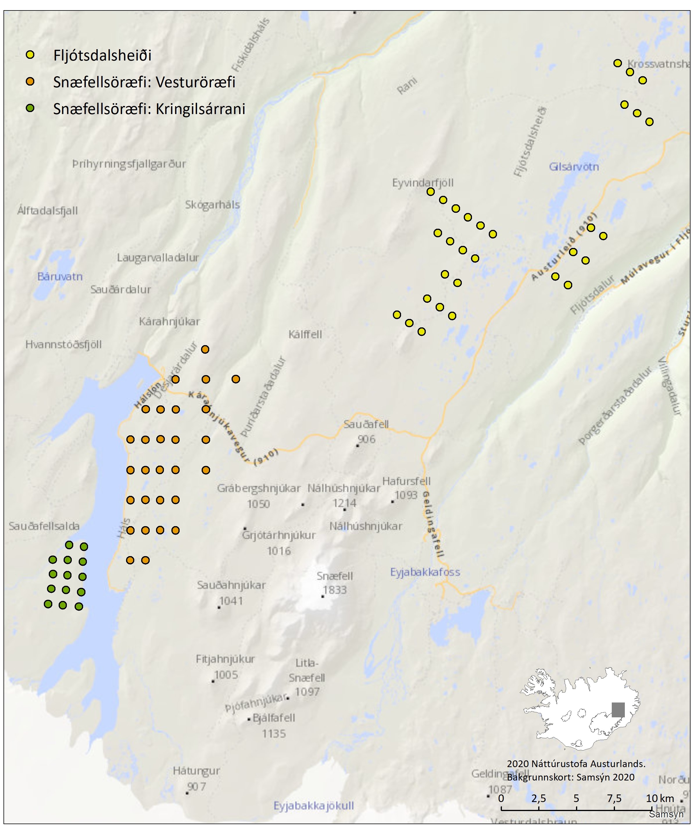
Figure 1. Research sites in Snæfellsöræfi, in Kringilsárrani and Vesturöræfi, and Fljótsdalsheiði.
Extensive geese grazing was recorded in 2015, more noticeable than in former observations. Other changes in vegetation were not detected. Kringilsárrani is a lush pasture compared to other highlands in Iceland and, therefore, important for grazing.
According to the reindeer counting since the year 2000, Fljótsdalsheiði heath was favored for summer grazing in 2000-2008, but few animals were found in the area in 2011-2016. The lichens cover, which the only reindeer graze, was substantially reduced between observations in Fljótsdalsheiði, but little change was detected within other plant groups.
In Vesturöræfi wilderness was a wide range of signs of gees or/and reindeer grazing in 2017. Little changes in vegetation occurred since the last observation, but grass cover increased in gravel-bed areas where seeds had been distributed. In addition, aeolian deposition from banks of the Hálslón lagoon was seen on vegetation and in the air close to the lagoon during summer 2017. Still, no clear vegetation changes were observed that could be related to aeolian deposition.
The results of vegetation assessments in the years 2015-2017 in Snæfellsöræfi and Fljótsdalsheiði indicate that grazing is probably the biggest factor in changes in vegetation in the area, and further monitoring of vegetation will be adapted to those results. In addition to on-site vegetation measurements, the vegetation index in the aforementioned areas has been compared for several years with the help of satellite images. No obvious changes in growth were seen based on the development of the vegetation index in the years 2000-2017, but the value of the coefficient in the last years of the period was highest.
In the summer of 2019, wire baskets were placed on the part of each research area in Kringilsárrani and Fljótsdalsheiði to protect that part from grazing by larger grazing animals. In the summer of 2020, wire baskets were also installed in Vesturöræfi. Sheep, geese, and reindeer graze in the study area. However, it varies between areas. Therefore, protected reference sites of this kind can provide interesting and scientifically important information about vegetation conditions and the variables behind the development of the ecosystem.
Changes in vegetation have occurred in Kringilsárrani, Vesturöræfi, and Fljótsdalsheiði since 2006, but they vary between areas. According to an extensive study, there are no direct impacts of Hálslón on the vegetation of these areas. The results of this study are now available in a peer-reviewed article.
Updated: June 6, 2024
Source: Landsvirkjun (2024) og Náttúrustofa Austurland (2024).
Metrics, Targets and Monitoring Protocol
Vegetation can change due to various reasons and it is important that monitoring allows for that.
Major influencing factors:
- Natural causes e.g. climate changes
- Changed grazing stress
- Reduced sheep grazing in recent years (general development).
- Movement of grazing stress due to grazing areas flooded by Hálslón reservoir.
- Pink-footed geese grazing
- Future aeolian deposition from Hálslón reservoir
What is measured
- In research sites, vegetation is monitored, e.g. total cover, the cover of plant species, and height of vegetation. (Impact of construction: indirect).
- Vegetation coefficient (NDVI). (Impact of construction: indirect).
Monitoring Protocol
Vegetation will be monitored in research sites in the area and the results will provide information on changes in species composition and vegetation cover. Furthermore, remote sensing (satellite images) will be used to monitor changes on a larger scale and monitor changes in growth factor (NDVI).
Vegetation measurements are carried out every 10-15 years and research fields will be visited every five years. Then the labels are reviewed and obvious changes are looked for.
Criterions for changes in vegetation will be developed in consultation with experts.
Target
Detect and monitor possible changes in vegetation in areas that might be affected by the Kárahnjúkavirkjun power plant.
Possible countermeasures
Landsvirkjun initiates action to stop aeolian deposition.
Changes of indicator
At the 2017 annual general meeting, an amendment was approved.
This indicator was originally number 26.1. It was then named Vegetation in Vesturoraefi and can be found under that number in documents of the project from 2005 and 2006.
The indicator number has been changed twice.
| Year | Nr. | Indicator name |
|---|---|---|
| 2020 | 2.6.2 | Vegetation in Snæfellsöræfi and Fljótsdalsheiði |
| 2007 | 2.28 | Vegetation in Snæfellsöræfi wilderness |
Baseline
Before the preparations for the Kárahnjúkar Power Plant, vegetation studies had been carried out (OS81002/VOD02 Icelandic only) in the area. In connection with research on reindeer, vegetation measurements were made in areas that the animals choose above others (OS-83073/VOD-07 Icelandic only). In the summer of 2000, research on vegetation was also launched to classify habitats in the area (NÍ-01004/LV-2001/020 Icelandic only). To get information about the baseline situation in the area approx. As part of it went under Hálslón, the vegetation condition was examined in 2006-2008. On the one hand, coverage and growth (NDVI growth factor) were investigated with the help of satellite images in the years 2002, 2007, and 2008. On the other hand, research fields were set up in three areas in Snæfellsöræf and Fljótsdalsheiði, and they provide the possibility of repeated measurements that can provide information on vegetation changes. An important part of the definition of the basic condition is to realize possible underlying changes that may have occurred before construction began, whether those changes are related to weather conditions or changes in grazing pressure.
Rationale for Indicator Selection
Kárahnjúkavirkun power plant's impact on vegetation will be most in the highlands in Vesturöræfi wilderness and Kringilsárrani area. Vesturöræfi wilderness is a valuable area since vegetated areas located that high above sea level are not very common and also because animals (sheep, geese, and reindeer) utilize the area for grazing. Hálslón reservoir will diminish vegetation in Vesturöræfi wilderness plus erosion in Hálslón's coast could cause aeolian deposition in remaining vegetation closest to the reservoir.
Landsvirkjun will take on extensive protective measures to prevent sand from blowing to the surrounding areas. Regardless, monitoring vegetation in the area is considered important if those preventive measures will not be sufficient. In addition to direct countermeasures, research is conducted to reinforce vegetation to withstand aeolian deposition and experiments to react to aeolian deposition f.ex by seeding Lyme grass.
Original Rationale for Indicator Selection
The Kárahnjúkar power project will impact vegetation in the highlands, most notably vegetation in Vesturoraefi. The area is valuable since vegetated areas located high above sea level are not very common. In addition, several species use Vesturoraefi for grazing (sheep, goose, and reindeer). The Hálslón Reservoir will remove some of the vegetated lands. Still, erosion on the shore of Halslon Reservoir could also result in sand blowing to the vegetated areas closest to the reservoir. Landsvirkjun will take on several measures to prevent sand from blowing to the surrounding areas. Regardless, monitoring vegetation in the area is considered important if those preventive measures will not be sufficient. An indicator monitoring changes in vegetation will signal if vegetation is deteriorating, which will help determine the need for the restoration of vegetation. The Agricultural University of Iceland is already doing extensive research in the area whose aim is to improve the vegetation in the area as necessary.
From phase I/II report on indicators and baseline from April 2005
Further reading

LV-2018-095 Gróðurvöktun á Vesturöræfum
Náttúrustofa Austurlands hefur vaktað gróðurfar á Snæfellsöræfum og Fljótsdalsheiði og hófst vöktunin árið 2006. Markmið rannsóknanna er að kanna langtímabreytingar á gróðri vegna hugsanlegra áhrifa Kárahnjúkavirkjunar og þá einkum Hálslóns.
Á Snæfellsöræfum fóru rannsóknir fram í Kringilsárrana og á Vesturöræfum. Niðurstöður mælinga á Vesturöræfum sýndu litlar breytingar á gróðri á milli áranna 2007 og 2017. Heildargróðurþekja breyttist lítið en þó mátti sjá mun á þekju víðitegunda. Ástand gróðurs benti ekki til aukins beitarálags og gróðurstuðull gaf til kynna meiri grósku á árunum 2014-2017 en árin á undan.
You can view more material related to the indicator by clicking on the link above.

