
Progress
Ufsárlón reservoir and Jökulsárgöng tunnel came into use in the fall of 2008. The filling of the Ufsárlón reservoir started on September 11, 2008, and the valve of the Jökulsárgöng tunnel was opened on October 16, 2008. At that time, Fljótsdalur Power Station began to utilize water from the Hraunasvæði area. The final preparation of the overflow channel in the Ufsárlón reservoir was done in the summer of 2009 and finished on August 10 of the same year. At the beginning of September of the same year, improvement work was done on the bottom duct of the Ufsárlón reservoir. Operations in the area finished in September 2010.
In an average year, the discharge to the waterfalls in Jökulsá í Fljótsdal river is controlled from August 10 to October 1.
During the period from mid-June to early October 2023, flow from Ufsarlón was diverted into the channel of Jökulsá in Fljótsdal. The water balance in the Fljótsdalsstöð reservoir area was above average in 2023. The chart shows the flow at Hól compared to the average flow of Jökulsá in Fljótsdal.
| Year | The tunnel opened (date) | Number of days with controlled discharge | Tunnel closed (date) |
|---|---|---|---|
| Average year | August 10 | 52 | October 1 |
| 2010 | July 16 | 67 | September 21 |
| 2011 | August 18 | 58 | October 15 |
| 2012 | May 31 | 129 | October 7 |
| 2013 | July 18 | 59 | September 15 |
| 2014 | June 13 | 104 | September 25 |
| 2015 | - | 0 | - |
| 2016 | June 16 | 124 | October 18 |
| 2017 | May 26 | 169 | November 11 |
| 2018 | May 26 | 116 | September 21 |
| 2019 | June 11 | 131 | October 20 |
| 2020 | June 20 | 92 | September 20 |
| 2021 | June 30 | 93 | October 1 |
| 2022 | June 17 | 116 | October 11 |
| 2023 | June 17 | 106 | October 1 |
The summer water flow of Jökulsá í Fljótsdal River can be seen on Landsvirkjun's web.
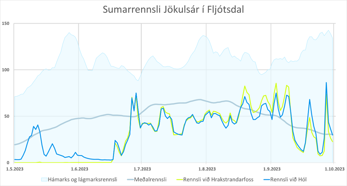
Figure 1. The summer water flow of Jökulsá í Fljótsdal river in 2023
Labels:
- Rennsli við Hrakstrandarfoss: The green lines show the flow through the overflow and bottom channel of Ufsarlón just above Hrakstrandarfoss, which is the highest waterfall in a series of waterfalls in Fljótsdalur.
- Rennsli við Hól: The blue line shows the river's water flow by Hóll farm. The flow meter is located above Fljótsdalsstöð Power Station before the discharge from the power station merges with Jökulsá í Fljótsdal River.
- Meðalrennsli: The red line estimated the average flow by Hrakstrandarfoss waterfall.
- Lágmarks- og hámarksrennsli: The blue background shows the estimated maximum and minimum water flow by the Hrakstrandarfoss waterfall.
The average flow, together with the minimum and maximum flow, is according to data from 1958-2014.
At present, Hrakstrandarfoss waterfall can expect some flow in late summer when the Hálslón reservoir has been filled. Still, there may be some water flow in early summer due to the thaw. Figures showing summer water flow from 2010-2022 can be downloaded here.

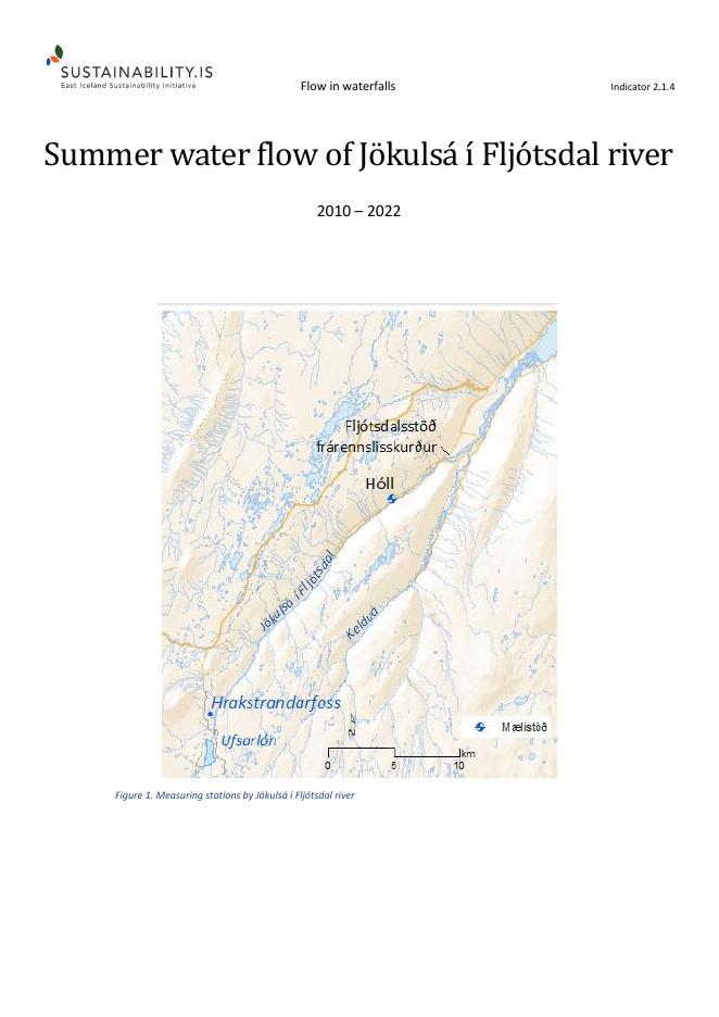
Figure 2. Measuring stations by Jökulsá í Fljótsdal river.
Updated: December 6, 2024
Source: Landsvirkjun 2024
Metrics, Targets and Monitoring Protocol
What is measured?
The number of days with controlled discharge in waterfalls (Project effect: Indirect).
Monitoring Protocol
Part of regular operation of the power station. Information is gathered simultaneously.
Targets
During average year controlled discharge will be in waterfalls in Jökulsá í Fljótsdal river from August 10 to October 1.
The ruling of the Minister for the Environment from December 20, 2001, sets 20 preconditions for the operation of the Kárahnjúkavirkjun power plant. Condition no.10 stipulates that the project developer shall utilize overflow water systematically during the tourist season and endeavour to maintain average water flow in Jökulsá í Fljótsdal river and Kelduá river in July and August in years when water is enough. In years with less water, the developer shall emphasize having water flowing in the channel of Jökulsá í Fljótsdal river and Kelduá river during the tourist season as overflow water allows.
Possible countermeasures
Water flow in waterfalls is maintained as close to normal as possible.
Updated: July 22, 2016. Reviewed August 2, 2017.
Changes of indicator
In the annual general meeting in 2016, a change in wording was approved.
| Original text | Changed text |
|---|---|
|
What is measured? Number of days with normal discharge in waterfalls |
What is measured? Number of days with controlled discharge in waterfalls |
The rationale for the change:
According to the monitoring protocol, the number of days with normal discharge in waterfalls will be measured. There is no normal discharge in the waterfalls, and all flow and discharge are under control; therefore, it's right to use the word controlled.
This indicator was originally number 30.1. It was then named Flow in waterfalls and can be found under that number in the project documents from 2005 and 2006.
The indicator number has been changed twice.
| Year | Nr. | Indicator name |
|---|---|---|
| 2020 | 2.1.4 | Flow in waterfalls |
| 2007 | 2.3 | Flow in waterfalls |
Baseline
Landsvirkjun has published a report on the effects of the Kárahnjúkavirkjun power plant on waterfalls (LV - 2008/089 (Icelandic only)). This report provides support for the baseline studies.
Generally, a waterfall is defined as water falling vertically from an edge, usually made of rock. In rapids, the waterfalls down a slope or ledges that are not high enough for the water to fall vertically. The report (above) does not distinguish between waterfalls and rapids and uses the term waterfall for both. It varies how intensely the waterfalls have been studied in the rivers covered. The Kelduá and Innri- and Ytri Sauðá rivers have been thoroughly researched. All waterfalls and many rapids have been photographed to a certain geodetic height defined in the report.
In the other rivers, waterfalls have not been counted and registered as thoroughly, but Landsvirkjun relies on information from people with local knowledge. No river has been researched all the way up to the glacier edge. With more accessible access to these rivers, it will be easier than before to gather information about waterfalls and rapids in the area because of the new roads in the area.
The initial harnessing plan for the Kárahnjúkavirkjun power plant included the following rivers: Jökulsá á Dal, small rivers that fall into Hálslón reservoir, Grjótá in Vesturöræfi wilderness, Þuríðarstaðadalsá, Hölkná, Laugará, Bessastaðaá, Jökulsá í Fljótsdal, Hafursá, Kelduá, Grjótá á Hraunum, Innri Sauðá, Ytri Sauðá, Fellsá and Sultarranaá.
The ruling of the Minister for the Environment on the Environmental Impact Assessment (EIA) for the Kárahnjúkar Hydro project reduced the scope of the project - causing the following rivers to be excluded from the plan: Grjótá á Vesturöræfum, Þuríðarstaðadalsá, Hölkná, Laugará, Bessastaðaá, Hafursá, Fellsá, and Sultarranaá.
In October 2008, the Landsvirkjun administration decided to put the harnessing of Ytri- and Innri Sauðá on hold for an undefined period. The information in table 4 comes from the previously mentioned Landsvirkjun report LV-2008/089 (Icelandic only). It includes all rivers from the initial harnessing plan. According to the original harnessing plan, the number of waterfalls refers to the number that will be or could have been affected.
| Name of river | No. of waterfalls | Harnessing plans | Comments |
|---|---|---|---|
| Jökulsá á Dal | 1 | River now harnessed | One waterfall was created with the harnessing of the river |
| Hliðarár sem falla í Hálslón | 6 | River now harnessed | Waterfalls disappear |
| Jökulsá í Fljótsdal | 20 | River now harnessed | Waterfalls higher than 2 m up to an altitude of 626 m |
| Kelduá | 33 | River now harnessed | All waterfalls and rapids up to an altitude of 620 m |
| Grjótá á Hraunum | 3 | River now harnessed | Photos missing from the report |
| Innri Sauðá | 5 | Harnessing postponed | Pictures of two waterfalls in the report |
| Ytri Sauðá | 11 | Harnessing postponed | All waterfalls and rapids up to an altitude of 691 m |
| Grjótá á Vesturöræfum | 1 | Min. for the Environment's decision: River not harnessed | Further research recommended |
| Þuríðarstaðardalsá | ? | Min. for the Environment's decision: River not harnessed | Further research recommended |
| Hölkná | 1 | Min. for the Environment's decision: River not harnessed | Further research recommended |
| Laugará | 2 | Min. for the Environment's decision: River not harnessed | Further research recommended |
| Bessastaðaá | 4 | Min. for the Environment's decision: River not harnessed | Further research recommended |
| Hafursá | 1 | Min. for the Environment's decision: River not harnessed | Further research recommended |
| Fellsá | 2 | Min. for the Environment's decision: River not harnessed | Further research recommended |
| Sultarranaá | 1 | Min. for the Environment's decision: River not harnessed | Further research recommended |
According to table 1, the Kárahjúkar Hydro project affects at least 63 waterfalls. Seven waterfalls disappear, but one is created. The discharge in 56 waterfalls is reduced for the main part of every year. The harnessing of two rivers has been postponed, and these two rivers contain at least 16 waterfalls.
Harnessing plans for seven rivers have been abandoned (Grjótá and Þuríðarstaðadalsá are two names for the same river. The upper part of the river is called Grjótá and the lower part Þuríðarstaðadalsá). These rivers contain at least 12 waterfalls, and the total waterfalls in waterways in the original harnessing plan are at least 91.
Rationale for Indicator Selection
In the river Jökulsá í Fljótsdal, there are many waterfalls along a 30 km stretch from Eyjabakkar to Norðurdalur valley, where the river drops by 600 meters. Amongst them are the waterfalls Eyjabakkafoss, Tungufoss, Kirkjufoss, Faxafoss, and Gjögurfoss. On a 20 km stretch from Eyjabakkar to Kleif farm in Fljótsdalur valley, there are 15 waterfalls more than 30 m high. There are also waterfalls in Kelduá river and other rivers in the Hraun area from which water will be diverted to the power plant. In Jökulsá á Dal river, there are no waterfalls. Still, in some of its tributaries, there are waterfalls such as Sauðárfoss in Sauðá river and Kringilsárfoss (alias Töfrafoss) in Kringilsá river.
Kárahnjúkar Power Plant will impact waterfalls in several ways. Some waterfalls will disappear, for instance, Sauðárfoss and Kringilsárfoss waterfalls, that will be submerged in the reservoir formed by the damming of Jökulsá á Dal river. Other waterfalls that are not submerged will change due to the control of discharge and storage of water in reservoirs. This applies to the majority of waterfalls in the rivers Jökulsá í Fljótsdal, and Kelduá river. Those waterfalls will have reduced water flow while the reservoirs are filling. After the filling of Hálslón reservoir (before mid-August in an average year), the operation of the power plant will be managed so that the discharge in the waterfalls in Jökulsá í Fljótsdal river and Kelduá river will resemble natural conditions.
From phase I/II report on indicators and baseline from April 2005
Further reading
Indicator 2.1.4 - Summer water flow of Jökulsá í Fljótsdal river 2010-2022
Summary on summer water flow of Jökulsá í Fljótsdal river
In 2008, a report was published on the impact of the Kárahnjúkar power plant on waterfalls. You can see informative information and many beautiful pictures of waterfalls that have disappeared from view and others that were allowed to stay there.